 606 is lovely, very rural little road which, after traveling 10 miles across the rolling valley floor (steep grades - up to 20% on one short hill) goes up and over a 1500 ft high ridge and then joins highway 615. Highway 779 looked, on my map, like it headed south from 606 just before the big ridge. It didn't. I decided to press on regardless, knowing that I would eventually get to 615. I did, but it was quite a climb and descent before that. I headed south on 615 and, eventually found a restaurant for lunch. I was quite hungry and hot and tired by that time. The day was hot and muggy with a good head wind blowing out of the south.
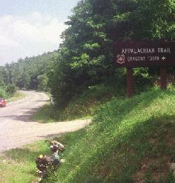
After lunch I rode south to New Castle and, mainly because of the head wind, turned back east to Catabawa instead of continuing south. About 10 miles down 213 I stopped at an access point for the Appalachian Trail to rest and have a snack. I visited with some guys coming off of the trail as I rested, then I headed on toward Catabawa. A small grocery store was located a few hundred yards down the road (!) so I stopped there for a coke and then rode into Catabawa to see where the 779 came out. I found it and also found that it was marked 698/779. I think I passed 698 when I was on 606! I know I passed 666 and it was named White Church Road and ran next to an abandoned (white) church.
I rode back to highway 785 and headed towards Blacksburg on the AC route. My bad map had cost me several extra hours, a half mile of climbing, and a lot of energy on this very hot day. This part of the ride was 4H: Hilly, Hot, Humid, and had Head winds.
Shortly after I started down 785 a recreational cyclist caught up with me. I never got his name, but he is a Materials Engineering undergraduate student at Blacksburg and a very nice young man. I teach computer science. I used to teach physics, and I have done graduate work in Electrical Engineering, so I we had a lot to talk about. We talked all the way to the road headed south for Christiansburg, and then he rode along with me, away from his destination, for another five miles. It was very nice to have someone to talk to and it really perked me up. My fatigue simply vanished in the pleasure of the conversation. Another cyclist joined us as we neared the Christiansburg turnoff. Neither of my riding companions, who both regularly ride this part of the Bike Centennial route, had seen any other tourists this summer! Where were you?
Getting into Christiansburg involved riding up a seeming endless hill - my fatigue came back - and, once I was in town, it was hard to find a place to eat or a place to stay. I went through town on the AC route and, as near Centrallia Washington, AC had found the steepest road in town. I think it is the steepest road I've ever seen!
I tried zigzagging up it, but there was too much traffic. I couldn't ride straight up it in my 23 inch gear, so I walked. Even that was hard, but the hill was only a few blocks long. The other side of the hill was nice and the route was a good way around the center of Christiansburg, but that hill!
The AC route from Christiansburg to Radford was closed for construction, so I had to take highway 11. This is a busy and hilly part of 11 near Christiansburg, but it gets pretty good near Radford. Unfortunately, it goes in on the side of town away from the AC route and, because I wanted to follow the AC route out in the morning, I had to ride through town to get to the motels near I-81. I got a noisy, overpriced, room at the Comfort Inn, but it was all that was available. Because of the noise, I did not sleep well that night and, as a result, I overslept in the morning. It did have a good continental breakfast. 100 miles of a hard days ride.


