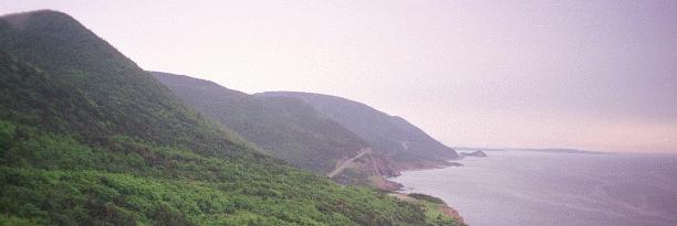
 The Cabot Trail on the west side of Cape Breton, near Corney
Brook Campground
The Cabot Trail on the west side of Cape Breton, near Corney
Brook Campground Day 30
I rode through the Cape
Breton Highlands National Park today, starting from half a mile outside the
Ingonish entrance and ending a dozen miles beyond the Cheticamp entrance.
Park employees at both ends were quite impressed that I was going to / could
do it in one day, although the entrance to entrance distance is only about
70 miles. I also got cheered along the way and called 'tough' by some folks
that apparently saw me in route and after I left the park. Aw gee, it
weren't nothin much...
I wasn't very impressed with my B+B last
night (worst I've seen, more like a rooming house than a B+B and not very
well maintained), but I did sleep well and they did serve a good breakfast.
I entered the park about 9 AM - paying the same $3.50 as the RVs. My first
impression was that there were lots of services and that the road was good.
Then I got to the pretty part along the ocean. Very nice views, moderate
traffic, hilly with some pretty steep, but relatively short, hills.
Before Niel's Harbor the road heads inward and climbs over a 100 meter or so
high ridge. Niel's Harbor looked neat, but I decided to ride on to Cape
North before stopping. There was road construction (I'd been seeing lots of
trucks) for several miles after Niel's Harbor and then a quite rural ride
over a 250 meter high hill. The grade was gentle and it was hot. I'm getting
acclimatized, I think 75 F is hot! There was an intermittent head wind which
helped keep me cool.
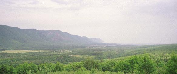 Looking north towards Cape
North
Looking north towards Cape
North
At Cape North I met the Australian tourists who I'd
met last week south of Halifax. They were coming from Cheticamp and planning
to spend the night in Ingonish. We had a nice visit and then I rode on to
Morrison's Restaurant in Cape North for an excellent lunch. After Cape North
I, rather nervously, rode off towards Big North, the worst climb on the
Cabot Trail. It is about 10 miles out of Cape North, with most of that
distance being down a lovely, and gentle, valley floor. Midway on, you can
see the road heading up the side of the ridge ahead. Did I mention that the
area west of Cape North is full of rather large ridges? Those ridges are
1500 or so feet high. Quite pretty, but not easy to ride over.
My
book say's the climb is 7% average grade for the first few kilometers and
then a 15% grade for the last .7 Kilometer. My impression was that the early
part was 15% alternating with pretty flat and the last part was all 15%. It
was a rough climb. My 19" low gear isn't low enough for a 15% grade on
a loaded bike, so I ended up grinding along a less than 4 mph while
zig-zagging when traffic permitted. I made it, but I don't think I could
have kept it up for more than another few hundred meters vertical. The climb
was about 400 meters. The head wind was really strong (25 mph?) on some
parts of the climb and almost gone on others. It was nice when the wind was
moderate, but unpleasant when it was absent (hot!) or too strong. The views
during this climb were, for a person from Western North Carolina, nice but
not spectacular.
After the climb there is a reasonably flat
section across/along the top of the ridge, then a downhill pretty much like
the uphill. I stopped before the downhill to eat a candy bar and drink some
water. Then zoom. I was holding 40 - 42 mph on the downhill into a pretty
good headwind and not tucked. Steep.
After the downhill things were
pretty flat/gently downhill until after Pleasant Bay. I stopped in Pleasant
bay for a light second lunch - you eat when you get the chance on this ride
- and headed up MacKensie's Ridge. That was about 300 meters of climbing
with, my book says, an average slope of 10%. Averages don't mean much in
this context. There were 15% or steeper grades on this climb as well, but
they didn't last as long. The climb finishes (well you keep climbing, but
not nearly as fast) with a long straight section at 10%. The earlier part of
this climb as some great views back up the coast.
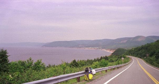 Pleasant Bay from the start
of MacKensie's Ridge
Pleasant Bay from the start
of MacKensie's Ridge The next 10 miles or so is a gradual
rolling climb to the highest point on the trail, French Mountain, at 455 M.
North tops out at 445 M. Nice, but, with the exception of the overlook down
to Fish Cove, not great. I did see three moose on this stretch, one in the
woods near the road and two crossing the road -the only moose I've seen.
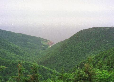 Fish
Cove from the Cabot Trail At the highest point on the road
there is some strange metal structure in a chain link fence enclosure (weird
enough that I almost took a picture), but no sign. A mile or two later at
405 M there are signs saying 'French Mountain, 455 Meters.' Strange. Shortly
after those signs there is an outstanding descent to sea level. A great ride
and the views are 'to die for.' At the bottom is Corney Brook Campground. I
wanted to stop and spend the night. Corney Brook is situated in the middle
of some of the most beautiful scenery (beach and hills) that I have ever
seen. This is breathtaking stuff.
Fish
Cove from the Cabot Trail At the highest point on the road
there is some strange metal structure in a chain link fence enclosure (weird
enough that I almost took a picture), but no sign. A mile or two later at
405 M there are signs saying 'French Mountain, 455 Meters.' Strange. Shortly
after those signs there is an outstanding descent to sea level. A great ride
and the views are 'to die for.' At the bottom is Corney Brook Campground. I
wanted to stop and spend the night. Corney Brook is situated in the middle
of some of the most beautiful scenery (beach and hills) that I have ever
seen. This is breathtaking stuff.
After you get down to sea
level, you go back up and down and up, etc, rather like Coastal Highway 1 in
California and even more beautiful. This continues till the Park ends 4
miles north of Cheticamp. This is Acadian country, lots of french stuff.
Cheticamp has a neat church, visible for many miles as you ride in from the
north, and some good places to eat but it was to busy and too touristy for
my taste. I did check with one Inn about rates, but it would have cost me
over $100 CD to eat supper, stay the night, and eat breakfast (Free
Continental Breakfast!). It didn't seem worth it so I rode on towards
Margaree (hmm, I was just in Margaree, Nfld).
I stopped at Flora's,
a gift shop and ice cream parlor, for a milkshake and some bread. They had
the usual Vanilla, Chocolate, and Strawberry, but, when I jokingly protested
the limited choice, the woman said; 'OK, what do you want?' I said pineapple
and she fixed me a very good pineapple milkshake, the first she had ever
fixed. Such service!
Fortified I headed on down the rather narrow
road with too much traffic. Then it got really windy. There were no trees
because the wind was too strong for them to grow. I had seen signs for
Germaine B+B earlier, and now, with the wind howling, I reached it. I
stopped, could find no one home, and found the owner across the street. A
very nice, if very windy, place. They have to repaint the windward wall
yearly because storms 'sand blast' the paint off. I walked/was blown down
to the ocean and sat in great beauty (and not much wind - the bank blocked
it), after cleaning up. Nice people and reasonable ($35 CD) rates. I'm not
looking forward to riding out of here tomorrow -that wind is strong! - but
I'm sure I'll enjoy my stay.
Tomorrow I'll head for Port Hastings.
It is getting on time to leave Cape Breton and ride along the northern shore
of NS to New Brunswick.

 Previous Page Next Page