
Day 32
Another long short day. Heading south,
really south west, means heading into the prevailing winds and they
prevailed pretty well today! They are forecast to be worse tomorrow. Shades
of riding across the plains!
I'm at a down home (Slovak style 8^))
B+B near the northern coast of NS. I'm about 35 miles from Pictou at the
Country Inn B+B. Since I'm upstairs and my bike is outside downstairs, I
can't give exact figures. I stopped here because I was tired of cranking
into headwinds and hills. I've had two relatively hard days since I did the
hardest part of the Cabot trail and my legs haven't had the rest they need
to recover. Moreover, it doesn't look like they'll be getting it in the next
few days.
I left my B+B / motel about 9 this morning heading down
the Sunrise Trail. That trail actually begins just across the TCH from the
drive to the Cove Motel. It is good that the owner of the motel told me that
since, unlike the other 'Trails' I have ridden, the Sunrise trail is not
signed, not even with a highway number (!) for the first 23 miles. It is
marked on the NS map and the route number, 4, is given, but there isn't a
clue at the start or anywhere on the road until it ends when it intersects
the TCH 23+ miles later. It is a nice ride through a pleasant agricultural
area reminiscent of the US midwest.
At the intersection where route
4 ends, I met Mike from Boston who had ridden from Alaska and was heading
for Nfld and planning to ride to its eastern end. He works for HP and is
maintaining a web site on his trip. I have his card and will be sending him
email (including these reports) as soon as I get net access. While we were
visiting, a third tourist rode up. This one is German and had started from
Halifax. He was also headed to Nfld. I tried to talk them both into going
to Nfld via the Cabot trail (it would add a day or two to their rides), but
both seemed put off by the big hills. Hmm, those hills aren't much compared
to what those guys are going to encounter in Nfld. The German tourist
claimed not to be in very good shape yet he was planning to ride some really
desolate, hilly, and windy routes in Nfld. I hope he knows what he is
getting into!
 I rode the TCH to Antigonish, stopping for a poor, but not
cheap, lunch at Goshen. This section of the TCH this is part of the Sunrise
Trail. Then the trail and I then headed north on route 4/ route 337. The TCH
was easy riding with, almost always, a good shoulder, but it was also
unpleasantly noisy and basically boring. The head wind, which had been
gentle earlier, had increased to 10-15 mph or so. I was concerned about
following the Sunrise Trail because of the wind. This trail runs southwest
down the coast, directly into the wind after first going north / northeast
to Cape George. It is at least 20 miles longer than taking the more direct
TCH or route 4 with some TCH. I was worried that, if I took it, I would not
be able to get to Pictou today. I was right about that, but things still
worked out OK.
I rode the TCH to Antigonish, stopping for a poor, but not
cheap, lunch at Goshen. This section of the TCH this is part of the Sunrise
Trail. Then the trail and I then headed north on route 4/ route 337. The TCH
was easy riding with, almost always, a good shoulder, but it was also
unpleasantly noisy and basically boring. The head wind, which had been
gentle earlier, had increased to 10-15 mph or so. I was concerned about
following the Sunrise Trail because of the wind. This trail runs southwest
down the coast, directly into the wind after first going north / northeast
to Cape George. It is at least 20 miles longer than taking the more direct
TCH or route 4 with some TCH. I was worried that, if I took it, I would not
be able to get to Pictou today. I was right about that, but things still
worked out OK.
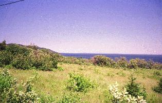
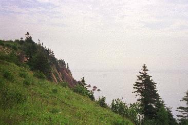 The ride up to Cape George started by heading northeast over a
long series of 100 - 200 foot high ridges. Those climbs seemed interminable,
but the road finally reached the ocean, or at least close enough to see the
ocean. Then it headed north to the Cape. On this section of the ride I
watched an eagle soaring nearby. The long range views of Cape Breton Island
were also superb. As Cape George got nearer, the road got hillier,
culminating in 300 foot plus climbs at the cape and after the cape. It was
beautiful, but hard riding. I stopped for a second, better, lunch at a take
out near the Cape. The first place to eat since Antigonish some 20 miles
back. The next place was 27 miles further on down the coast.
The ride up to Cape George started by heading northeast over a
long series of 100 - 200 foot high ridges. Those climbs seemed interminable,
but the road finally reached the ocean, or at least close enough to see the
ocean. Then it headed north to the Cape. On this section of the ride I
watched an eagle soaring nearby. The long range views of Cape Breton Island
were also superb. As Cape George got nearer, the road got hillier,
culminating in 300 foot plus climbs at the cape and after the cape. It was
beautiful, but hard riding. I stopped for a second, better, lunch at a take
out near the Cape. The first place to eat since Antigonish some 20 miles
back. The next place was 27 miles further on down the coast.
As I
rode up and around the Cape I hit the head winds again. I had asked at the
take out place and knew there was a convenience store at Malignant Cove - a
pretty place despite the name. Thanks to lots of hills and headwinds, it was
after 4:30 when I got there and I was starting to wonder if I could make it
even to New Glascow - only 33 miles away, but 33 hilly miles into a stiff
headwind! I stopped and called NS Tourism. They had nothing between
Malignant Bay and New Glascow.
I went into the store, got a Pepsi and some candy bars, and asked them
about places to eat and places to stay. They first told me that there was
one place to eat (fast food) about 10 miles down the road. Then they
suggested 'John's B+B' about 15 miles down the road. They said John would fix
me a good supper as well as a good breakfast. They were right.
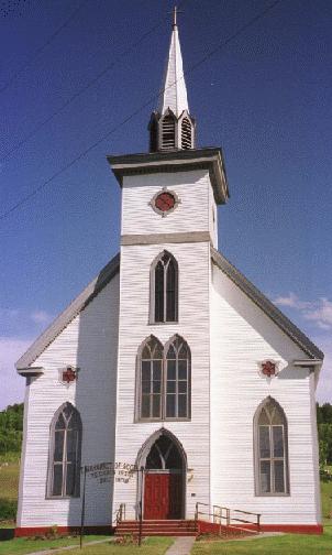 I rode on down to
John's, which took about an hour and a half into the wind (only two hills
over 100'), stopping to take several photographs of a beautiful, and rather
typical, NS church. John is Slovakian, 70 years old, and quite interesting.
He does a lot of stuff here
- the B+B, a sod farm, bee hives, and, on Saturday he cuts hair. He was a
Barber in Ontario (and lots of other things) before coming here, for reasons
of health, in the early 80's. He came to Canada in 48 after being taken by
the Nazis as a Jew on Christmas Eve of 1944 (one grandmother was Jewish -
that was enough) and getting released on New Years Day 1945 through the
intercession of a powerful family friend.
I rode on down to
John's, which took about an hour and a half into the wind (only two hills
over 100'), stopping to take several photographs of a beautiful, and rather
typical, NS church. John is Slovakian, 70 years old, and quite interesting.
He does a lot of stuff here
- the B+B, a sod farm, bee hives, and, on Saturday he cuts hair. He was a
Barber in Ontario (and lots of other things) before coming here, for reasons
of health, in the early 80's. He came to Canada in 48 after being taken by
the Nazis as a Jew on Christmas Eve of 1944 (one grandmother was Jewish -
that was enough) and getting released on New Years Day 1945 through the
intercession of a powerful family friend.
I got the tour of the
sod farm (impressive) and the bee hives (buzzing) and a good supper and my
clothes washed and some interesting conversation. My room is nice, but it
has lots of east facing windows with only lace curtains, so sleeping till
7:30 may be a challenge. There is also a mosquito buzzing around in here. Oh
well, I'm glad that John was here for me. I like him and I've learned yet
another point of view on NS.
Tomorrow I grind on down the coast.
Winds are forecast at 20 mph from the southwest. I think I'll go into New
Glascow to look for a bicycle shop. I need a spare derailleur cable and a
replacement spare spoke.


