Winter Vistas on the Blue Ridge Parkway
These
images were created from digital photographs taken in late February,2000 on
the Blue Ridge Parkway and of the Blue Ridge Parkway from Mount Mitchell. I
created the panoramas using Photovista, a program that 'splices' digital
images together, so that I could do a better job of showing you what the
Parkway really looks like in the winter.
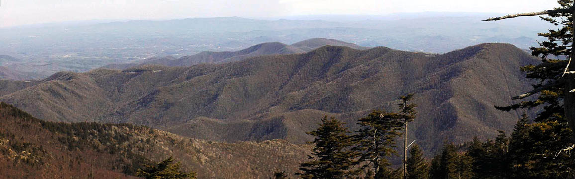
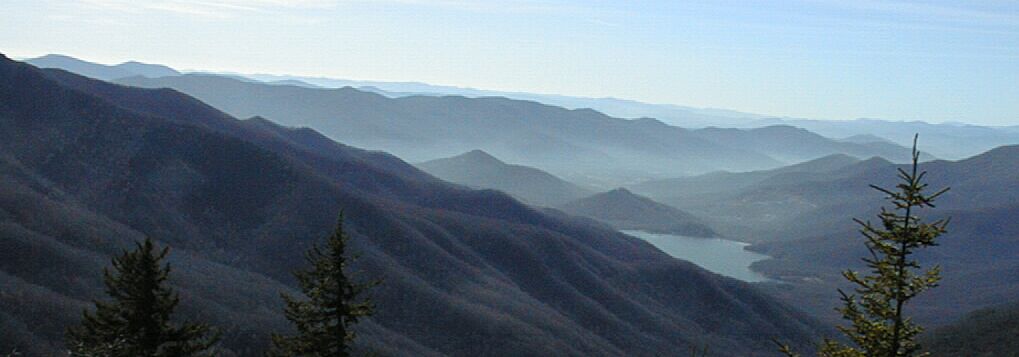
The Parkway climbing towards Green Knob, as
seen from Mt Mitchell
Green Knob, which is at the right hand side of this image, has a Fire Tower,
just visible as the white dot at the top of the powerline cut running up the
side, on its top. In the saddle just to the left of Green Knob, you can see
an overlook area which gives an excellent view of the Black Mountains. The
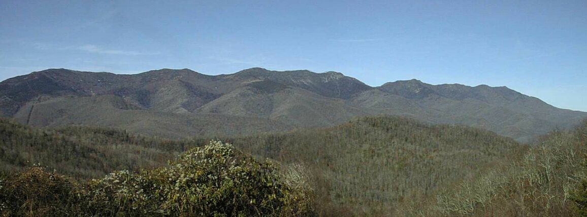
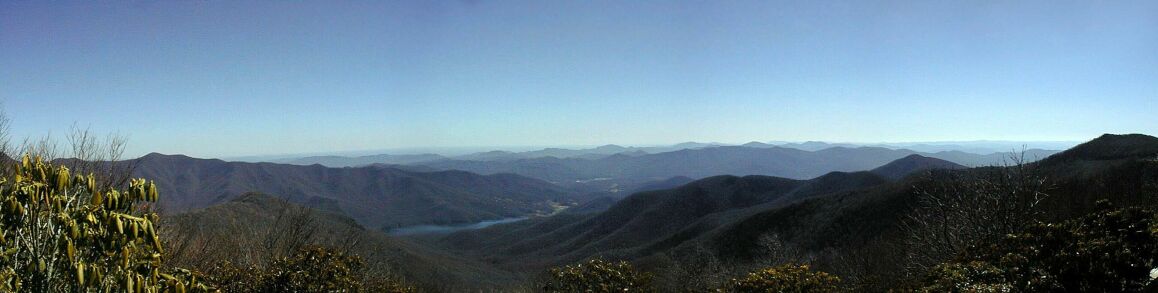
panorama below is the Black Mountains as seen from an overlook north of
Green Knob, I think the one nearest the left edge of the shot above.
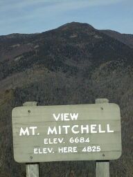
 The shot on the right, taken in December from that overlook, shows Mt
Mitchell as seen from the Parkway near Green Knob. Note the elevations. The
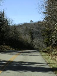
shot on the left shows the Green Knob fire tower from the Parkway. After
Green Knob, the Parkway drops down into a valley at 4200 feet before
climbing back up to 5200 feet where a road, NC 128, heads off up Mt
Mitchell. Towards the left side of the first panorama above, you can see the
several sections of the Parkway as it climbs toward Green Knob. That climb
starts at about 3000 feet
The shot on the right, taken in December from that overlook, shows Mt
Mitchell as seen from the Parkway near Green Knob. Note the elevations. The
shot on the left shows the Green Knob fire tower from the Parkway. After
Green Knob, the Parkway drops down into a valley at 4200 feet before
climbing back up to 5200 feet where a road, NC 128, heads off up Mt
Mitchell. Towards the left side of the first panorama above, you can see the
several sections of the Parkway as it climbs toward Green Knob. That climb
starts at about 3000 feet
After 128, the Parkway climbs to about 5750 feet, this is the highest point
on the Parkway north of Asheville, before descending to Balsam Gap and then
climbing once more to Craggy gardens at near 5700 feet. Here is a shot of
North Fork Reservoir, taken in December 1999, from near the highest point on
the Parkway.
In February, I did a panorama that includes that same reservoir as seen from
just north of the Craggy Gardens Visitor Center. Note the slightly rolled up
Rohdodenron leaves. These leaves are a good thermometer - this degree of
roll means it is fairly warm - about 40F. When it is well below freezing
those leaves are rolled so tightly that they look like green pencils!
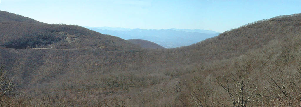
After Craggy, the Parkway does a long downhill; almost ten miles with only
one short uphill. This panorama of the Parkway from the Parkway shows one of
my favorite views. On a clear day (unheard of now except in the winter!)
you can see a long way through Potato Field Gap (that is the name - one of
my favorite mountains is named Potato Knob!). Note that the Parkway is
fairly level at Potato Gap - I ride about about 12 mph heading north and 25
mph heading south.
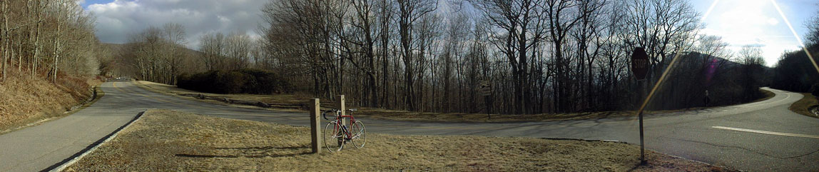
The road to Craggy Gardens Picnic area leaves the Parkway just north of
Potato Gap. Here is a panorama showing both the north and south parts of the
Parkway at that road. It also shows my bike leaning against an empty sign
post. When the Parkway is open, there is a sign there for the picnic area.
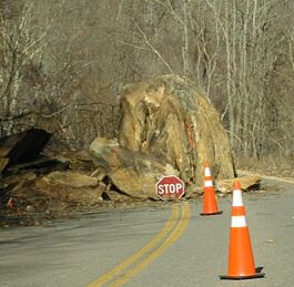 This section of the Parkway, from Bull Gap near Asheville to 128, the road
up Mt Mitchell, is usually closed from January through March. In a normal
winter there would be some snow in this picture and I wouldn't be able to
ride much north of Craggy because that part of the Parkway would be covered
with snow and ice. It was covered a few weeks ago, but the warm weather
since then has melted almost all of the ice and snow. This section if the
Parkway will, despite the warm weather, still be closed for a while: check
out that rock sitting in the middle of the Parkway between mileposts 372 and
373! Rock pieces, some of them pretty big, fall on the Parkway in the winter
as a result of water freezing and thawing, but this rock is the biggest
single rock I've seen on the road. I think it will be a while before the
Park Service can remove it, repair the road, and open the Parkway. Of
course, as a bicyclist, I like having the Parkway closed. Riding on the
closed Parkway is much like hiking in the back country. Peaceful, solitary,
quiet, and requiring some caution since, if I have an accident, no one is
likely to come along and help me anytime soon.
This section of the Parkway, from Bull Gap near Asheville to 128, the road
up Mt Mitchell, is usually closed from January through March. In a normal
winter there would be some snow in this picture and I wouldn't be able to
ride much north of Craggy because that part of the Parkway would be covered
with snow and ice. It was covered a few weeks ago, but the warm weather
since then has melted almost all of the ice and snow. This section if the
Parkway will, despite the warm weather, still be closed for a while: check
out that rock sitting in the middle of the Parkway between mileposts 372 and
373! Rock pieces, some of them pretty big, fall on the Parkway in the winter
as a result of water freezing and thawing, but this rock is the biggest
single rock I've seen on the road. I think it will be a while before the
Park Service can remove it, repair the road, and open the Parkway. Of
course, as a bicyclist, I like having the Parkway closed. Riding on the
closed Parkway is much like hiking in the back country. Peaceful, solitary,
quiet, and requiring some caution since, if I have an accident, no one is
likely to come along and help me anytime soon.
I once rode
up Mt Mitchell in a more typical March where there was still snow and ice
covering the Parkway, but only in fairly short stretches. I had to dismount
and carry or roll my bike across half a dozen patches of snow and ice, but
for some reason, I decided to ride across the last one. Dumb. Water covered
ice is very slippery! So I fell down. No big deal at 10 mph. Then I got up
and decided to pick my bike up while standing on water covered ice. Even
dumber! I still remember the popping sounds my knees made as my feet slid
out to the sides of my body. Knees weren't make to bend that way, and, as I
fell, I realized that I was five miles or more from the nearest human being
on a closed road. If I couldn't walk or ride, it was going to be a very long
crawl! That was a scary thought. Fortunately, although I had a hard time
walking, I could ride OK. I rode on up to the top of Mt Mitchell and back
home again that day, but I've been a bit more cautious while riding the
closed Parkway since that experience.