Day 9 Seaside OR to Longview WA
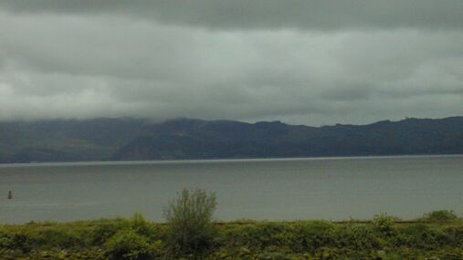
Looking across the Columbia from Astoria at about 1:30 PM
This was a good day for riding in the rain. I delayed leaving Seaside till the rain there let up at about 11 AM, but still rode about fifty of the seventy five miles I covered today in light rain. The main problem, other than the fact that my chain now needs to be cleaned and lubed <grin>, was the !#$%! RV drivers on US 30 who could not bother to pull over as they passed me in the rain. Those rigs throw a lot of spray and, since US 30 has a narrow shoulder with a guard rail on several long hills, I couldn't get away from it. I also felt a bit insecure about the possibility that one of them would drift over into my space and I would have no escape option. Note that most RV drivers weren't rude, but there were too many that were.
The ride from Seaside to Astoria was easy, if a bit damp. I chose to ride 101 rather than going by Lewis and Clark Rd which is on the ACA route. I was glad I did when I go to Astoria and saw that Bus 101 was closed at Lewis and Clark Rd. US 101 from Seaside is a good road to ride in the rain. It had a good shoulder almost all of the way, few hills, and little scenic value. Lewis and Clark, which I rode in '96, is prettier, but also longer and hillier. I rode 101 because I wanted breakfast as soon as possible in Astoria. I had eaten tea and pop tarts in my room before I left, so I was ready for a more substantial breakfast when I stopped at a Denny's just before the bridge. I had a good breakfast and a nice visit with some folks from Chattanooga who are touring by car.
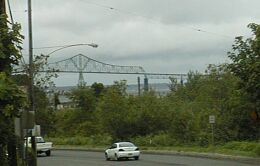
The bridge to Washington, from several miles away
I have now ridden into Astoria on both bridges from the south, but I haven't ridden the big bridge over the Columbia. It is a very impressive sight, rising hundreds of feet into the air. Not nearly as impressive as the Confederation Bridge from PEI to New Brunswick, but this one is, I think, legal to ride over. The climb up looks hard.
Passing under the big bridge, I headed east on US 30 through downtown Astoria. I rode US 30 to Westport where the ferry goes over to Washington (Puget Island). This is 26 miles with several big hills - I'd guess over 1500 feet of climbing. It has a highly variable shoulder for the first few miles, but then, except for those long up hills where the passing lane means a narrow shoulder, it has been repaved since I rode it in '96, and has a good shoulder. It also has too much traffic, especially RVs.
The highest point, which is only a few miles from Westport, is about 650 feet above sea level, i.e. Astoria. Then there is a great descent that takes you most of the way to Westport. Watch out for the shoulder which has some strange damage done near the top. It looked like it could cause a bike to crash. Other than that, it was, although cold and wet, great fun. When I unpacked tonight, I discovered that I probably left a liner glove up on the summit. I had both liner gloves and Gore Tex mitts in the top of my clothing pannier and, when I reached in for something to keep my hands warm on the 30+ mph descent, I came up with the mitts. They worked well, but now I only have one light weight liner glove. I suspect the other one fell out when I pulled the mitts out.
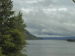
The Cathlamet Channel from Cathlamet WA
The ferry runs at 15 minutes after the hour, and I arrived at 4 PM, so the wait, in very light rain, wasn't bad. The bicycle fare is $1. When I got to Washington, the rain had stopped and, except for wet roads, caused me no further problems. The sun even came out several times and I could see some blue sky (!) for the entire ride on the Washington side. I rode through Cathlamet - not a lot of nostalgia there since a too soft bed at the hotel gave me a sore back - and onto WA 4 for the twenty five mile ride to Longview. I stopped near Cathlamet for a snack, and again in Longview for supper before finding an inexpensive motel in downtown Longview. The ride 'along the river' is nicer on this side - less traffic, better views, better roads - but still hilly for the first ten or more miles. Then it is really along the river and pretty flat. Coming into Longview on 4 is easy, if a bit urban, riding. I did have one idiot in Longview who amused himself by coming a bit close and blowing his horn right beside me, but almost everyone else was very polite. Actually, the Washington drivers were a lot more considerate than the drivers on the Oregon side.
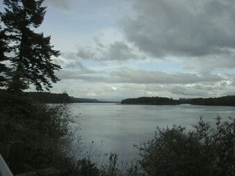
The Columbia River from WA 4, with blue sky
Tomorrow, I head north to US 12 and then west to Packwood. That is about 90 miles, and I'm hoping for less rain than tody, but the forecast isn't good.