
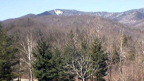
The Black Mountains, which include Mt Mitchell - the highest point in the eastern USA, are roughly in the center of the map segment shown above. Highway 128 is the road that goes from the Blue Ridge Parkway to the top of Mt Mitchell. To ride around the Black Mountains starting from Asheville, you could ride the Parkway to Highway 80, then ride 80 to Micaville, 19 to Burnsville, 197 to Barnardsville and on to where it intersects 19/23, then go south to Asheville to complete the loop. That would be a bout a 100 mile ride with over 8000 feet of climbing. I tried that routing on a (relatively) warm December weekend and had mechanical problems which prevented me from completing it. I didn't get to try it again till March, but, in March the Parkway was covered with snow in the section south and west of Mt Mitchell so I rode from Asheville to Black Mountain to Old Fort to 80 and then up 80 across the Parkway. This route is about 20 miles longer but has a little less climbing. It was also snow free in late March.
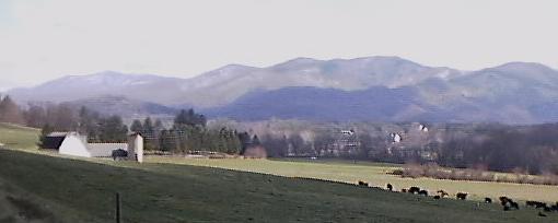
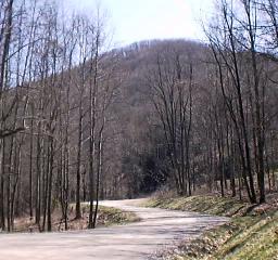
The map doesn't have enough detail to show my route from Asheville to highway 80. The route I use to get to Black Mountain follows SR 81 along the Swannanoa River in Asheville, then briefly heads east on US 70 before going north on Riceville Road to just after that road goes under the Parkway. Then it heads east again on Old Farm School Road which intersects another Riceville Rd just before that road gets to Warren Wilson College. The Old Fam School road is really nice riding, as is the second Riceville Rd. The first shot below is Old Farm School Road shortly before it ends at Riceville Rd. The second shot is the view looking south from Riceville Rd.

The road that goes around the Warren Wilson Campus is Bee Tree Rd. Following it to the east leads to Old US 70 which continues east. It intersects US 70 shortly before the town of Black Mountain. Riding US 70 is OK, although not as nice as the roads we've been on earlier. After Black Mountain, we get back on Old US 70 which is good riding. Unfortunately it deteriorates just past Ridgecrest and ends a short distance later. After Ridgecrest, you turn north on a deteriorating concrete road. Half a mile later, that road is blocked by a barricade. It is possible to go around that barricade and ride the unmaintained closed section of Old US 70 - watch out for broken glass near the other side of the barricade! I chose to follow the dirts road that exits from 70 just before the barricade. It takes a longer and gentler route down the mountain and then rejoins Old US 70 after the closed section.
 The condition of this road depends on recent weather and road maintenance,
but it is generally ride able with a touring bike. This time it would have been
fine even on my road bike. A bit bumpy perhaps, but my sub 200 gram tires
could have handled it. After less than two miles of dirt road down the
beautiful mountainside at mostly moderate grades - this road parallels the
railroad tracks - you get back to wonderfully smooth pavement which carries
you on into Old Fort. A very nice ride - great scenery, very little traffic and a
long downhill!
The condition of this road depends on recent weather and road maintenance,
but it is generally ride able with a touring bike. This time it would have been
fine even on my road bike. A bit bumpy perhaps, but my sub 200 gram tires
could have handled it. After less than two miles of dirt road down the
beautiful mountainside at mostly moderate grades - this road parallels the
railroad tracks - you get back to wonderfully smooth pavement which carries
you on into Old Fort. A very nice ride - great scenery, very little traffic and a
long downhill!
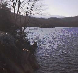
After Old Fort life is not as good. You are back on US 70 which has moderate traffic and, usually, no shoulder. Not fun, especially at shift change time at the furniture plants in Old Fort, but you only have to put up with it for seven miles or so. Then it is time to turn north on SR 80. On this ride I stopped for a meal at a roadside snack bar about a mile before SR 80. I'd ridden about 40 miles at this point and I was hungry.
 SR 80 is part of The Assault on Mt Mitchell.
On the Assault Web page the say something
like climbing begin in earnest when you start
up SR 80. It isn't true. The first few miles of
80 are flat. Then you climb a bit as you
approach Lake Tahoma - another beautiful
part of this ride. Once 80 starts to climb, it
also gets very pretty. That helps to take the
pain out of the 2000 feet you have to climb
before 80 reaches the Parkway. Most of that
climb occurs in the last few miles. Just after
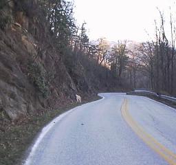
Buck Creek the road surface gets rougher and climbing gets tougher. Those last few miles are steep (10%
grade) and curvy. At the top there are a series of switchbacks that seem to go on forever. Here is a view from
just before the Parkway looking back down the valley.
SR 80 is part of The Assault on Mt Mitchell.
On the Assault Web page the say something
like climbing begin in earnest when you start
up SR 80. It isn't true. The first few miles of
80 are flat. Then you climb a bit as you
approach Lake Tahoma - another beautiful
part of this ride. Once 80 starts to climb, it
also gets very pretty. That helps to take the
pain out of the 2000 feet you have to climb
before 80 reaches the Parkway. Most of that
climb occurs in the last few miles. Just after
Buck Creek the road surface gets rougher and climbing gets tougher. Those last few miles are steep (10%
grade) and curvy. At the top there are a series of switchbacks that seem to go on forever. Here is a view from
just before the Parkway looking back down the valley.
When I reached the Parkway it was 40 F ( it had been about 55 F when I got on 80 - 2000 feet up means quite a bit colder) and it was about 6PM in the evening. I hadn't left Asheville till 1 PM because of weather and other obligations, but my timing was good because I only had about five downhill miles to go to my nights destination; Don Patterson's home near the Mt Mitchell golf course. This route would be ride able in one day by a strong rider, but that wasn't me in March. Besides, half my purpose was to visit Don whom I hadn't seen since my last attempt to ride around the Black Mountains in December. Don and I had a good visit and I got a good nights sleep before the second half of my ride. I had ridden 60 miles and climbed about 4000 feet getting to Don's house. By luck, Don's house is at the midpoint of this ride both in linear distance and in climbing. There are (expensive) places (both a B+B and a Motel) to stay near Don's house and much less expensive places to stay in Burnsville which is an hour and a half farther on a bike.
Riding down 80 towards Micaville, following the Toe River valley which runs down the eastern side of the Black Mountains, is pretty easy for a while, but then you hit some hills afer Hamrick and again after Celo. It is nice long downhill into Micaville , but you've earned it. SR 80 is excellent riding from its start near Marion NC to Micaville. After Micaville you ride west on US 19. This isn't as much fun since it is a 55 mph highway with moderate to heavy traffic, but it does have a ride able shoulder most of the way. I rode it half a mile or so past where 197 turns off to the south in order to get a good meal before going back to ride 197. There are no services on 197 till well past Barnardsville.
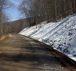
 The first 10 miles of 197 south of Burnsville are a great and quite gentle ride
following the Cane River. The Cane River valley runs up the west side of the
Black Mountains. You pass through Pensacola NC about a mile before the
end of this section. Then 197 becomes a dirt road which climbs out of the
Cane River Valley. The dirt section is 10.75 miles long and has almost as
much climbing as 80 coming to the Parkway. It isn't quite as steep as the last
part of 80, but it is a steady climb for several miles. This dirt road is also in
pretty good condition and would be OK for a road bike. There were a few
muddy bits on my trip, but it had just snowed heavily two days earlier.
The first 10 miles of 197 south of Burnsville are a great and quite gentle ride
following the Cane River. The Cane River valley runs up the west side of the
Black Mountains. You pass through Pensacola NC about a mile before the
end of this section. Then 197 becomes a dirt road which climbs out of the
Cane River Valley. The dirt section is 10.75 miles long and has almost as
much climbing as 80 coming to the Parkway. It isn't quite as steep as the last
part of 80, but it is a steady climb for several miles. This dirt road is also in
pretty good condition and would be OK for a road bike. There were a few
muddy bits on my trip, but it had just snowed heavily two days earlier.
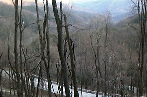
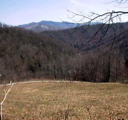 The views of the Black Mountains from 197
as it climbs the valley wall are great. This
photo shows the western side of the
mountains - they form a ridge running
roughly north south - near their northern
end. Mt Mitchell is near the southern end.
The views of the Black Mountains from 197
as it climbs the valley wall are great. This
photo shows the western side of the
mountains - they form a ridge running
roughly north south - near their northern
end. Mt Mitchell is near the southern end.
There was still snow on shaded areas above 4000 feet. This photo was taken a half a mile or so before Cane River Gap. The road near the gap runs alongside the creek. It sounded like a waterfall.
The ride down the other side towards Barnardsville was fast, a bit rough in places, and a bit muddy in some of the same places. The Cane River gap is about 2000 feet above Barnardsville. The first half a dozen miles are winding dirt road similar to the road up the Cane Creek side. I was coasting at 15 to 25 mph, with frequent braking for the turns. After the pavement began I was able to coast at near 30 mph most of the way into town. I think it took about four times as long to climb to Crane River Gap as it did to descend from it.
I stopped by the side of the road just after Barnardsville to fix my second lunch. It had taken me two and a half hours to cover about 25 miles and I was hungry. Don had given me four slices of good bread, some cheese, and mustard. I made cheese sandwiches and sat by the road watching the cars roar by as I ate. I was quite comfortable, but I discovered that the ground was damp when I got up. Oh well, riding shorts dry quickly. It was about 65 degrees and cloudy by this time. I also had a 10 mph or so headwind for most of the ride, which helped keep me cool while climbing but was a pain on the flatter parts of the ride.
There are three ways to get back to Asheville from Barnardsville: ride 197 till it crosses 19/23 and then head south through Weaverville, ride over Paint Fork and out Reems Creek Rd to Bus 19 south of Weaverville, or ride Dillingham Rd to near Dillingham and then ride up to the Parkway on Stoney Fork Rd and back down the Parkway to Asheville. Paint Fork Gap isn't too high, only a little over 3000 feet, and it is a very pretty ride, but the climb up is very steep (12% or so). Reems Creek would be great bicycling except that it has too much high speed traffic to be safe for bicycling. I've done it a number of times, but I don't like it. Dillingham Rd is lovely bicycling, but Stoney Fork is a long climb up a rough dirt road. This road is much rougher than the roads I'd ridden earlier on this loop and it is a big (1700 foot) climb. I took the easy way, 197. 197 after Barnardsville is a fairly wide two lane road with no shoulder. The lanes are wide enough and the traffic is light enough that it is good riding. It is even easier to ride 19 through Burnsville to 19/23, but that way misses some great riding on 197 and includes a lot of not so great riding on 19 and 19/23.
When I reached 19/23 I crossed under it and took the first left turn on the other side. It is still legal to ride on 19/23 (which is scheduled to become part of I-26 ) and there is a good shoulder on this part so it is relatively safe, but it is also very noisy and very smelly. If you ride on the roads adjacent to the freeway, the riding is much more fun. I rode south through Flat Creek and crossed back across 19/23 at the next exit. You can follow SSR 2207 all the way from 197 to Weaverville without having to deal with high speed traffic. From Weaverville it is pretty easy to ride into Asheville on Bus 19. I find this road much less dangerous than Reems Creek because traffic moves at 40 mph or so instead of 60 mph. There are places to stop to eat in Weaverville as well as on Bus 19, but from Burnsville to Weaverville there are only two service station type stop located on 197 not too far from 19/23. Carry food and water.
Each of the two days I took for this ride had about 60 miles of riding with some dirt roads and 4000 feet of climbing. Each day had some great riding, a lot of good riding, and a little bit of not so good riding. The dirt roads are good enough to ride with a road bike, but more comfortable on bike with wider tires. The views and the climbing are great as are the downhills.