
Fort Collins to Walden to Grand Lake and back to Fort Collins via Trail Ridge Road
Fort Collins to Walden - 110 miles with about 5500 feet of climbing
Al and I left Fort Collins about 7:30 AM, heading west through La Porte and turning from US 287 onto SR 14 at Ted's Place.. I was riding loaded, carrying about 35 pounds in front and rear bags with my tent poles and my sleeping pad on my rear rack.. We stopped at the store at Poudre Park, about 25 miles from Fort Collins, for a break, and then rode on to Rustic, about 22 miles on up the canyon, for lunch.
The Poudre climbs gradually (1% grade) for most of this distance, with occasional stretches, e.g. the narrows, where the grade increases to 3%. I used my Vertec to 'measure' the grades by reading the rate of climb in feet per hour and using that with the speed in mph to calculate the grade. For example, a 1000 foot per hour climbing rate combined with a five mph speed, means I climbing 1000 feet or about one fifth of a mile for every five miles I ride; that is a 1 in 25 grade or about 4%. Not terribly accurate, but useful.
Poudre Canyon is nice riding, but it does not have a shoulder. At 8 AM on a week day this is not a problem, but at noon on a summer weekend it would be. After Rustic there is little traffic, even on a weekend. I enjoyed riding with Al and we were able to ride side by side and visit much of the way to Rustic. We arrived there at noon and had a good lunch. Service was very slow, so we didn't leave till after 1 PM. Al decided to ride on with me for a few more miles before heading home. His round trip distance was 98 miles.
After Al headed back, I cranked on up the canyon at little ways and then reached for my front water bottle. It wasn't there. I'd left it at the restaurant! Oh well, maybe I can catch Al before he reaches the restaurant. I turned around and cranked back down the canyon. The wind, which had been barely noticeable as a tailwind, was suddenly a pretty stiff head wind. It took me 3.5 miles of hard riding to catch Al. I borrowed one of his water bottles and headed back up the canyon. Al stopped at the restaurant and retrieved my bottle. This incident cost me about seven miles and half an hour, but I needed all (four - two on the bike and two in pockets on my front bags) of my water bottles.
Riding on solo was both nice and a bit lonely. I'm really constitutionally suited to solo riding: I am quite comfortable in my own company. Riding with someone means I devote some of my attention to them. Riding by myself I can devote my attention to my surrounds and/or to introspection. I get a great deal out of being in the world around me, seeing the plants and animals, smelling the land, feeling the mood of the country I'm riding through. I also like to talk to myself and to sing. Since I can't even remotely carry a tune, it is better for me to ride alone!
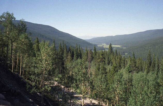
Poudre Canyon about 60 miles west of Fort Collins
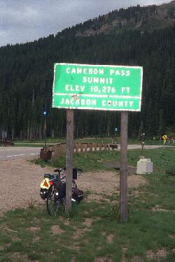
I enjoyed riding from Rustic west on 14. The climb was gentle, the road was rolling, the valley kept changing and the scenery was great. On the other hand, it was 27 miles of climbing, gentle at first, then getting steeper for the last ten miles, and I was running out of energy before I got to that last climb up to Cameron Pass. I was not enjoying myself at that point; the ride had become an endurance event, and I was just barely enduring. Moreover, the bugs were a real pain. When I had to slow down to five or six mph for the last hour of climbing, I immediately acquired several kinds of pests; two kinds of flies and mosquitos.
Riding became quite unpleasant as I tried to swat bugs before they bit me and to keep the bike on the road. I didn't always succeed at either, and I ended up ten feet off the road one time after swatting a mosquito that was sucking on my right shoulder. I didn't crash, but I sure wobbled around a lot. I tried to take a rest stop to eat a Cliff bar, but the small biting flies swarmed on me whenever I stopped so I ended up eating the bar as a I rode. I reached Cameron Pass at 5 PM. It took me almost four hours to cover the 27 miles from Rustic. Not fun, especially the last hour or so. If some kind soul had offered me a lift to the top of that pass, I certainly would have accepted. Fortunately (?) no one did.
After Cameron pass, life was good again. I put on my heavy gloves and bicycling coat at the top - it was chilly (in the high 50's) and I was exhausted - and then coasted at 35 mph down into North Park. North Park is a flat area surrounded by big mountains. The continental divide forms the south and west boundaries and the range that contains Cameron Pass forms the east boundary. My good touring book describes the middle of this region as 'rather bleak areas of sagebrush', but I think it is quite beautiful.
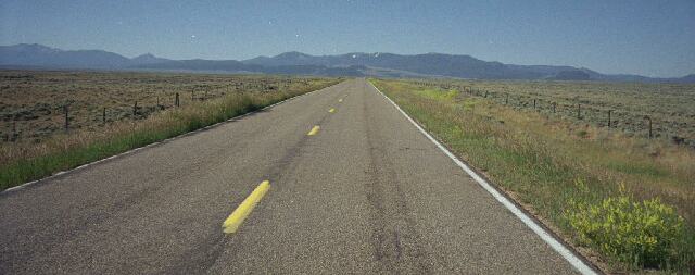
North Park
It is about ten miles from Cameron pass to Gould, which took half an hour to ride. Compare this to the two I hours I spent covering the last ten miles on the other side of the pass. At Gould there is a restaurant/bar - the Howling Coyote Restaurant and Lounge - which is much better than it sounds. I had a good supper there and, much restored, headed out towards Walden. There is a big KOA, with cabins, about two miles past Gould, but Walden is only twenty-two, mostly downhill, miles. I reached Walden about 7:15 after some of the best riding of the day. This day reminded me a little bit of riding from Rockport State Park to Winthrop WA over Rainy and Washington Passes. That was a similar distance and similar climbing through really spectacular country (north cascades), but the best part was the fourteen miles from Mazma to Winthrop down a rather dry (sagebrush again) and gentle river valley. Somehow spectacular doesn't cut it when I'm exhausted and hungry. Gentle riding after a good supper at the end of a hard day is what I like.
I stayed at the Hoover Roundup Motel. Not a good choice, because the acoustical isolation was lacking and I had the misfortune of having a neighbor with sleep apnea. I disconnected the antenna from the TV and used it, covering the screen with a towel, as a white noise generator. It was not my best nights sleep.
Walden to Grand Lake 75 miles with 3000 feet of climbing
I left Walden at 8:30 AM after a breakfast of sour pancakes at the Coffee Cup. Ah well, the coffee was good and I needed a lot of it to get going after yesterdays hard ride and last nights not too great sleep. I headed south on SR14/SR125. That is where I saw two Bike 76 signs. The only Bike 76 signs I've seen in Colorado, although obviously SR14 is Bike '76 in Fort Collins and some of the eastern part of the state.
I had a decision to make about half a mile south of town: SR 152 through Rand to US 40 east to Granby and then on to Grand Lake or SR 14 to SR 40 west to Steamboat Springs and then back on SR 40 through Kremling and on to Granby and Grand Lake the next day. Folks in Fort Collins and now in Walden said the 25 miles west of Kremling on 40 were really bad bicycling: heavy truck traffic, inadequate shoulders, etc. I decide to do the sane thing and shorten my trip by a day. This also had the advantage of making the second day an easy day sandwiched between two hard days. Not a bad idea considering how tired I was after riding form Fort Collins to Walden.
Riding south meant over 50 miles with no services and one pass. This sounds bad but is actually better than the ride to Steamboat. Rand has a store. It may be open? As it turns out it was open, but now sells only books and gifts. Rand is 22 miles down 125. For most of this distance the road runs through the Arapahoe National Wildlife Refuge. Nice. I saw a jillion prairie dogs, lots of birds including an eagle with a three or four foot wing span which flew alongside and in front of me, and no moose. Ah well, it was a really nice ride with and occasional car or, more often, pickup truck passing me. I saw lots more animals than people. The road is gently rolling for a few miles, then pretty flat, then it starts rolling again maybe three miles from Rand. I stopped at the store and sat on the porch while I ate my snack (a bagel and a Cliff bar) and drank water . There was a coke machine on the porch, but I didn't have the right change. The store opened at 10 AM and I visited briefly with the lady who owns it. She was commenting on the unusual weather: a bunch of days over 80 F when normally they only had one or two a year.
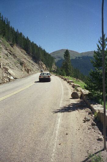
A few miles south of Rand, 125 enters the Arapahoe National Forest and, about ten miles south it crosses the continental divide at Willow Creek Pass. This would have been a nice ride except for two 'sportsmen'. The North Park Area is popular on weekend for hunters and fishermen. My landlady last night had warned me about traffic on Friday afternoon due to sportsmen coming into the area. Unfortunately I ran into two bad ones in the ten miles between Rand and Cameron pass. The first, and worst, one started blowing his horn a quarter mile behind me ("Get off of my road!") and then, when I didn't get off of his road - I really couldn't without crashing, roared up behind me and swerved (and this idiot was towing a trailer that could easily have hit me even if his truck didn't) around me, tires howling, with a foot or so of clearance. The second incident occurred while I was climbing the pass. A big motor home towing a boat came up behind me, hugging the white line. There was a little (6 inch?) shoulder, so I pulled over on to it expecting him to pull out a little to clear my bags. He didn't and I ended up going off the road into soft sand to avoid being hit. Since I was only going 6 mph at the time, this was not dangerous, but it sure gave me a bad impression of these 'sportsmen.' Note that there was very little traffic, so these were two out of maybe twenty vehicles that passed me in that ten miles. I don't think I'd want to bicycle in North Park on a weekend.
Things were better on the other side of the pass, and, except for those two jerks, drivers have been almost invariably polite. After Willow Creek Pass, there is a long and quite pretty downhill for about twenty miles. Then there is a several hundred foot climb and another few miles of downhill till 125 ends at US 40. US 40 has a good shoulder all the way to Grand Lake and moderate traffic. It was a pleasant ride. It is about three miles to Granby, where I stopped for a nice lunch at the Sunrise Grill, and another fifteen miles to Grand Lake. There is about a 1000 feet of climbing in that fifteen miles. I got to Grand Lake about 2:30 PM. I noticed lots of No Vacancy signs as I rode along the lake and even more as I rode through Grand Lake. Oops. Fortunately I had just talked with the owner of Bike and Hike in Longmont (he sells Top Touring tires and I needed another one for this ride) and he had told me about being in a similar situation. He stayed at the Shadowcliff youth hostel on a cliff overlooking Grand Lake. So did I and it was great. This is an incredible place next to where the Colorado river runs (in rapids) into Grand Lake. It cost me $13 for the night in their dormitory and for an afternoon spent sitting and reading on their porch. Such a deal! If you happen to pass through, ask how to find it. I asked at the library.
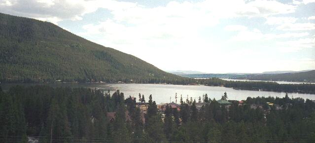
Grand Lake from Shadowcliff
Grand Lake is pretty much just a tourist town, but it sure is in a beautiful place. It has the lake, Rocky Mountain National Park and the Arapahoe National Forest all within hiking distance. It also has some decent places to eat and a lot of places designed to relieve tourists of their extra money. I enjoyed my stay there and I even got some sleep at the hostel.
Grand Lake to Fort Collins - 92 miles with about 5000 feet of climbing
I left Shadowcliff, the AYH hostel in Grand Lake about 7:30 AM, heading down, sharply down, into Grand Lake for breakfast. I left Grand Lake a bit after 8 AM, heading up, but not sharply up, to Rocky Mountain National Park and Trail Ridge Road.. Trail Ridge, like Mount Evans, is a famous ride for bicyclists in Colorado and it was one of my 'goals' for this trip. After paying my five dollar fee (do tandems cost ten dollars? Motorcycles are charged five dollars per rider) I rode on up the headwaters valley of the Colorado River.
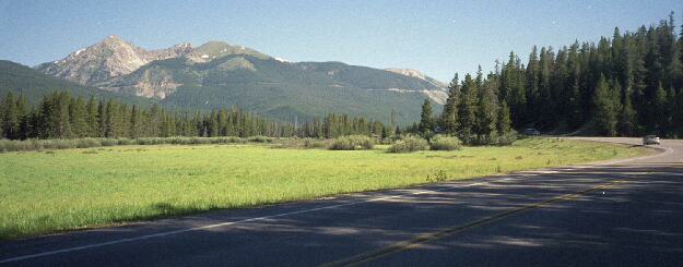
Riding up the Colorado River Valley
The first ten miles of this ride only climb about 1000 feet. The next fifteen miles climb 3000 feet. After twenty-five miles, it is pretty much down hill for the next twenty-five miles to Estes Park. The gentle ride from the entrance to the beginning of the real climb was nice, but a bit chilly. This ride goes through pine forest, and much the road was shaded at 8 to 9 AM when I was riding it. I did see first a lone elk and then, on the other side of the road, a group of elk. Darn funny looking deer...
The climbing starts with a thousand feet vertical or so of about 4% grade and then gets steeper above 10,000 feet. Traffic was light, the temperature was about ideal, and the views were 'to die for.' I was ready for a food break when I reached the 10,500 foot mark. I actually stopped at the '2 miles high marker - 10,560 feet' because there was a nice area to R+R (eat, drink, rest, and (don't tell anybody) pee). There is a picnic area just beyond this marker, but the, less official, place where I stopped was nicer. Bikes only, of course! I also collected a small rock for my daughter whose birthday was yesterday. A two mile high rock.
Looking Back from about 10,000 feet
Looking Ahead
Not long after the two mile high mark, Trail Ridge crosses the continental divide at Milner pass. This is beautiful area with meadows and marsh lands. The Poudre river, which I rode most of the way up two days ago, starts at Poudre Lake, just north east of this pass. Those waters eventually reach the Gulf of Mexico. On the other side of the pass, water flows down, reversing the path I've just been climbing, to the Colorado river and on to the Pacific Ocean. This area was the first place on this days ride where I felt that there were too many people.
You'd think crossing the divide would mean heading down, and it would if Trail Ridge followed the Poudre, but in this case it just means a brief stretch of level before heading up again on about a 6% grade. The remaining climbing, almost 2000 feet of it, takes you above tree line at about 11,500 feet and into a beautiful arctic tundra region. Of course the work you are doing to get there may overshadow the pleasure of seeing the new region. The fact that you can see the road climbing switchbacks a mile ahead of you also contributes to the feeling of 'what am I doing here? Why aren't I riding up in car instead of cranking up this endless hill?' Good question. The view is better from a bicycle?
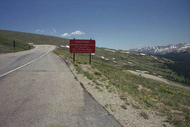
Tundra where the shoulder goes away
At about 11,500 feet, I stopped at the visitors center. There were far too many visitors there, but it is the only place on Trail Ridge to refill water bottles. All
 this
cranking up hill takes lots of water - I'd already gone through two and a half water bottles. Although the visitors center
was packed and every overlook was overfull, riding wasn't bad. Traffic was slow and drivers were polite. Most sections of
the road have good shoulders, although the shoulder goes away for the final climb to the top a mile or two past the
visitors center. I reached this point about 12:15 PM. It isn't all downhill after this, but there is only one more significant
climb about a mile further east. Then it is time to brake to avoid running into slow cars. Most of the downhill would be 30
to 40 mph coasting (that 4% to 6% grade again), but there are too many slow cars and RVs. I
spent over a hour (instead of maybe 40 minutes) getting to Estes Park. Let's see, four hours
to climb, including stops and a little over one hour to descend. Five hours into this ride and
I'd covered about 50 miles. I had 45 miles to go and about half of that was downhill. I'd gone
from 8,400 feet to over 12,000 feet and back to 7500 feet, but I still had 2500 feet of vertical
to lose. This image is looking east from the high point on Trail Ridge. The high point isn't
marked and there is no pullover, but their is enough room for a touring bike!
this
cranking up hill takes lots of water - I'd already gone through two and a half water bottles. Although the visitors center
was packed and every overlook was overfull, riding wasn't bad. Traffic was slow and drivers were polite. Most sections of
the road have good shoulders, although the shoulder goes away for the final climb to the top a mile or two past the
visitors center. I reached this point about 12:15 PM. It isn't all downhill after this, but there is only one more significant
climb about a mile further east. Then it is time to brake to avoid running into slow cars. Most of the downhill would be 30
to 40 mph coasting (that 4% to 6% grade again), but there are too many slow cars and RVs. I
spent over a hour (instead of maybe 40 minutes) getting to Estes Park. Let's see, four hours
to climb, including stops and a little over one hour to descend. Five hours into this ride and
I'd covered about 50 miles. I had 45 miles to go and about half of that was downhill. I'd gone
from 8,400 feet to over 12,000 feet and back to 7500 feet, but I still had 2500 feet of vertical
to lose. This image is looking east from the high point on Trail Ridge. The high point isn't
marked and there is no pullover, but their is enough room for a touring bike!
Coming down towards Estes Park I saw many bicyclists, but no tourists, climbing up. Actually I saw my first bicyclists of the day, who appeared to be lightly loaded tourists, near the visitors center which is close to the midpoint of Trail Ridge. Traffic was terrible coming up from Estes, and the eastern side of the Trail Ridge was hot and dry. The western side was, earlier in the day, cool and rather lush. I enjoyed the great downhill, albeit slowed a bit by traffic, but the riders coming up were grinding uphill in the heat with an almost constant stream of cars passing them. It didn't look like much fun to me. At the Estes Park Entrance to Rocky Mountain National Park, the line of cars waiting to get in was over a mile long! Literally everything in the park is already at or above capacity, so I wonder where those folks are planning to go once they do get in.
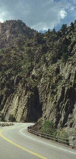 From Estes Park I continued on 34 down (after a little up) Big Thompson Canyon. Actually Trail Ridge Road is also 34 and, after its
high point, it roughly follows the Big Thompson River to Estes Park. On Trial Ridge, you are usually thousands of feet above the
river, but after Estes Park you ride right alongside it. This is another popular Colorado bicycle ride and, going down, it is an easy
ride. It has a good shoulder and wide lanes so, even on this heavy traffic day, I had no problems with traffic. This road was
completely rebuilt after it (and a lot of lives..) was destroyed by a flash flood in the late '70s, so, except for a few bridges near the top, the riding is excellent both
up and down. The canyon is pretty, but too built up for my tastes. All the buildings in the lower part of the canyon are new. In that flood, a sudden
thunderstorm dumped half a foot of rain on the headwaters which became a 30 foot high wall of water roaring down the canyon. A lot of the people who died
tried to outrun the water in their cars. Now there are signs in many Colorado canyons saying "Climb to safety in case of Flood."
From Estes Park I continued on 34 down (after a little up) Big Thompson Canyon. Actually Trail Ridge Road is also 34 and, after its
high point, it roughly follows the Big Thompson River to Estes Park. On Trial Ridge, you are usually thousands of feet above the
river, but after Estes Park you ride right alongside it. This is another popular Colorado bicycle ride and, going down, it is an easy
ride. It has a good shoulder and wide lanes so, even on this heavy traffic day, I had no problems with traffic. This road was
completely rebuilt after it (and a lot of lives..) was destroyed by a flash flood in the late '70s, so, except for a few bridges near the top, the riding is excellent both
up and down. The canyon is pretty, but too built up for my tastes. All the buildings in the lower part of the canyon are new. In that flood, a sudden
thunderstorm dumped half a foot of rain on the headwaters which became a 30 foot high wall of water roaring down the canyon. A lot of the people who died
tried to outrun the water in their cars. Now there are signs in many Colorado canyons saying "Climb to safety in case of Flood."
Coming down Big Thompson, I encounter bad headwinds. Sometimes I had to pedal just to keep moving! This is typical for these canyons and for almost the entire ride. Since the headwinds just slow down what otherwise would have been a really fast descent - I still hit 40 mph at one place - they didn't really cause me to work much harder, but they sure did dry me out. The effect is like riding across a desert at 40 mph with the hot dry winds literally sucking moisture from your body. At Loveland, which is maybe five miles of relatively flat (hot and windy..) riding after the end of Big Thompson, I stopped at the Dairy Delite (good place) for a quart milkshake. I needed the moisture and the food. Then I rode north on Taft Ave towards Fort Collins. It was about fifteen miles of pretty easy riding with a bit of tailwind. I got back to Al and Jane's house about 5:30 PM. A good three days of riding and a nice short tour!